Are you planning to travel a route through Ushuaia but don’t know where to start?
It’s a common feeling among travelers visiting Ushuaia, especially considering there are more than 117 scenic routes around this city at the end of the world. You will be amazed by the diversity of landscapes and options available for trekking enthusiasts.
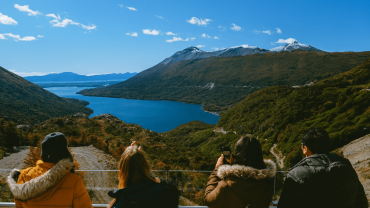
Ushuaia offers experiences for all levels: from easy trails covering just 10.31 kilometers with an elevation gain of 884 meters, to more challenging routes within the impressive Tierra del Fuego National Park, which spans approximately 70,000 hectares. Trekking in Ushuaia has become a must-do activity for anyone wishing to connect with Patagonia’s natural beauty. For example, Laguna Esmeralda is accessible through a hike of only about two and a half hours, while more adventurous hikers may choose to explore the Vinciguerra Glacier and Laguna de los Témpanos, two natural gems hidden in the Andorra Valley.
For those who prefer hiking in Ushuaia, there are 30 easy-rated trails perfect for beginners. However, if your passion lies in road adventures, the stretch from Río Grande to Ushuaia covers 362 kilometers of fully paved road, offering spectacular views of the “Heart of the Island” and its 100,000 hectares of protected forests and peat bogs.
In this guide, I’ll share the perfect 2025 itinerary, including the best of Ushuaia’s Route 3 and all the secrets I discovered during my journey to this magical corner of Argentina.

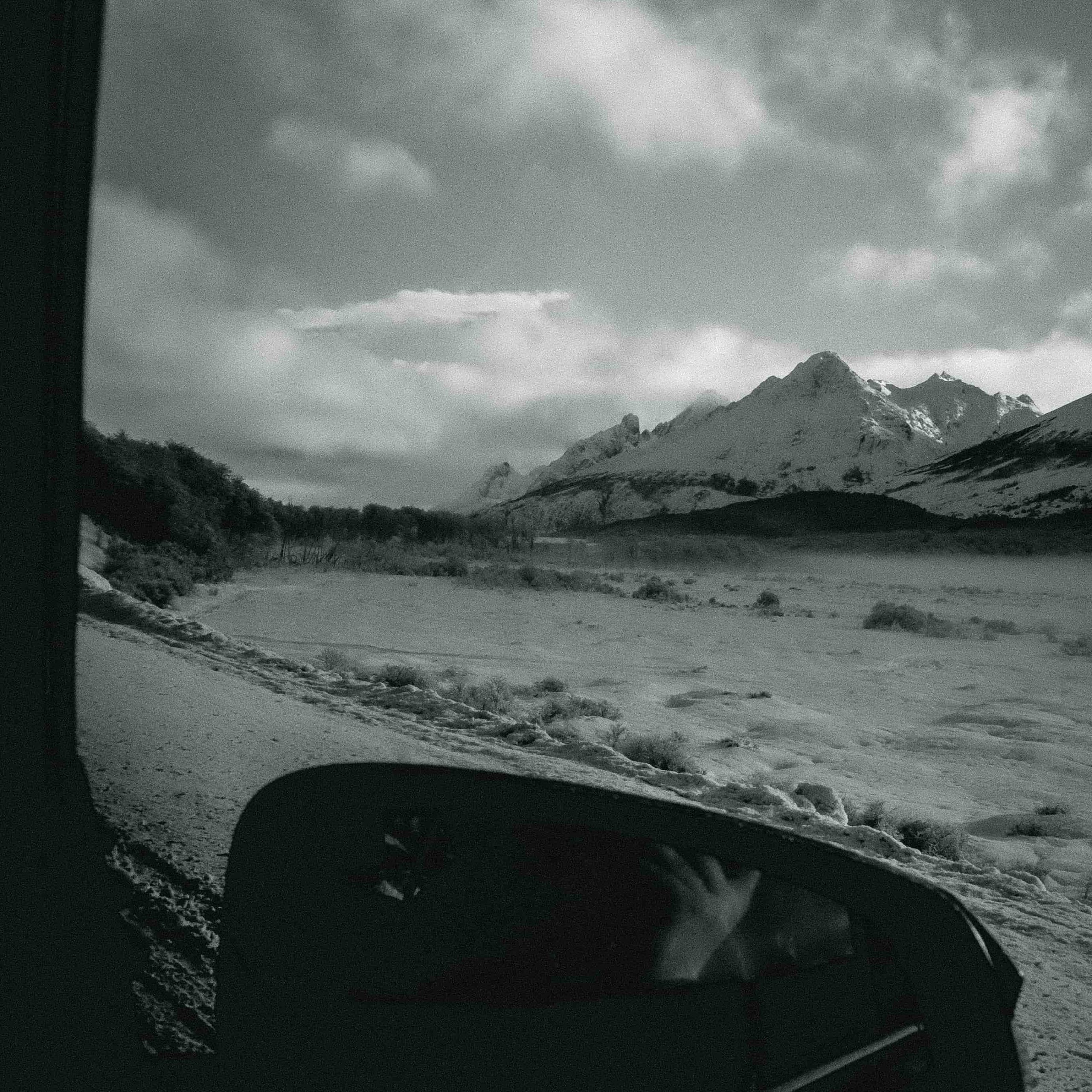
Ushuaia Route in the Snow
From Río Grande to Tolhuin: The Fuegian Adventure Begins
The Ushuaia route starts in Río Grande, a city located in the northeast of the island. The stretch toward Tolhuin represents the first leg of this adventure and covers approximately 108 kilometers. While traveling along National Route 3, the landscape changes dramatically as you move from the steppe area into the first patches of forest.
The drive from Río Grande to Tolhuin takes around 1 hour and 26 minutes, although daily public bus services are also available and take about 1 hour and 30 minutes. The road is entirely paved and in excellent condition, with a conservation rating of 9 out of 10.
As you move forward, you witness the gradual transformation of the landscape. The route winds through picturesque estancias and crosses a mix of hills, steppe, and rivers. This area marks the transition between the Fuegian steppe and the Andes Mountains, locally known as the “Ecotone.”
Upon arriving in Tolhuin, you will understand why it is called the “Heart of the Island”—the name comes from this very meaning in the Selk’nam language. This small town is strategically located on the shores of the impressive Lake Fagnano, also known as Khami or Kaken Shown in the Selk’nam tongue.
Lake Fagnano is undoubtedly Tolhuin’s crown jewel. It is one of the world’s largest lakes, covering 590 square kilometers and reaching depths of over 200 meters. This vast body of water stretches more than 100 kilometers east-west into Chilean territory.
Around Tolhuin, you will find three important provincial reserves: “Corazón de la Isla,” “Laguna Negra,” and “Río Valdez.” Along with the local “Río Turbio” reserve, they form a paradise for nature lovers and particularly for birdwatchers.
The region offers countless activities, including hiking, sport fishing, kayaking, cycling, and birdwatching. One particularly recommended option is the “Haiken chache” interpretive trail (meaning “Bird watching” in Selk’nam), ideal for spotting birds between September and March.
Nature and Trekking in Ushuaia: What You Can’t Miss
Upon entering Ushuaia, mountain trails become the undisputed stars of any well-planned Ushuaia route. During your exploration, you’ll discover that Tierra del Fuego National Park offers more than 40 kilometers of trails with varying difficulty levels—a true paradise for trekking lovers.
Among its natural gems, Laguna Esmeralda stands out for its beauty. The trail, of medium difficulty, crosses peat bogs and Fuegian forest before reaching a high-mountain environment. The trek takes roughly 4 hours round-trip and rewards hikers with intensely turquoise waters surrounded by snow-capped mountains.
For those seeking greater challenges, the hike to the Vinciguerra Glacier starts in the Andorra Valley. This high-difficulty trek takes around 8 hours round-trip and traverses forested areas, peat bogs, and high-Andean terrain. Nearby, the Ojo del Albino Glacier offers equally stunning scenery for more adventurous hikers, close to Laguna Esmeralda.
Inside the national park, the Cerro Guanaco trail is a considerable challenge, with a 6-kilometer (one-way) route and a total elevation gain of 900 meters. The trail is open from November to April and requires good physical preparation.
For more accessible experiences, the Hito XXIV trail borders Lake Acigami for 3.5 kilometers with spectacular views. Meanwhile, the 8-kilometer Coastal Path explores the marine coastal environment, offering unique panoramas of the Beagle Channel.
If you prefer easy options, the Castorera (200 meters), La Baliza (1,200 meters), and Mirador Lapataia (980 meters) trails are ideal and available year-round, allowing you to explore Fuegian ecosystems without demanding physical effort.
When planning your hiking in Ushuaia, remember to bring proper footwear, sufficient water, and clothing suitable for the fast-changing weather typical of this southern region. Every step on these trails showed me why Ushuaia is widely considered an unmatched destination for connecting with Patagonian nature.
Culture and History at the End of the World
Ushuaia’s cultural richness perfectly complements its natural wonders. Known as the “southernmost city in the world,” it has a fascinating history that long predates European arrival. The Yámana or Yaghan people—nomadic canoe dwellers—navigated these cold waters for millennia.
The name “Ushuaia” comes from the Yámana language and means “bay facing the west.” The Yámana developed remarkable survival techniques, building bark canoes where they kept a fire burning even while fishing and hunting.
Modern Ushuaia’s history began on January 18, 1869, with the establishment of an Anglican mission led by Waite Hockin Stirling. Later, on October 12, 1884, Commodore Augusto Lasserre officially founded the city, strengthening Argentine sovereignty in the region. A major turning point was the construction of the “Ushuaia Prison” in 1902, which operated until 1947 and contributed significantly to urban development.
Today, Ushuaia offers several unmissable cultural options.
-
The Museum of the End of the World has two locations: the Foundational headquarters at Maipú 173 and the Old Government House at Maipú 465.
-
The Maritime Museum and former Prison allows visitors to explore old cells and learn about the harsh conditions prisoners faced.
During your Ushuaia route, you cannot miss the End of the World Train, a recreation of the old railway used to transport prisoners to gather firewood. If your visit coincides with June 2025, you will also enjoy the National Festival of the Longest Night, featuring cultural, recreational, and artistic activities for all.
Ushuaia’s Film Festival has become one of the region’s major cultural events, receiving more than 2,800 film submissions since its creation four years ago. The festival promotes filmmaking, sustainable culture, and environmental awareness.
The extreme south of the Americas became known as the “End of the World” thanks to European expeditions that explored farther south from the 1500s onward. This historical designation adds a special charm to any Ushuaia route adventure.
Adventure on Wheels: Route 3 and Beyond

For those who love the freedom of exploring at their own pace, driving the Ushuaia route offers unique perspectives of this southern paradise. The iconic National Route 3 is more than just a road—it’s a transformative experience connecting contrasting landscapes across its 3,079-kilometer journey from Buenos Aires to Ushuaia.
The final stretch of Route 3 winds between mountains and forests, offering panoramic views of the Beagle Channel that are impossible to capture in photos. Along my route, I discovered that this last segment toward the southernmost city has sharp curves and significant slopes, so I recommend driving carefully, especially in winter when ice and snow complicate the journey.
Beyond the main route, the adventure continues on equally fascinating secondary roads.
The road to Estancia Harberton, for example, combines gravel and asphalt over roughly 85 kilometers from Ushuaia. Founded in 1886 by missionary Thomas Bridges, this historic estancia is home to the Acatushún Museum of Birds and Marine Mammals—a must-visit for nature lovers.
For the more adventurous, the road to Paso Garibaldi (the highest point of Route 3 at 450 meters above sea level) offers unbeatable panoramic views of Fuegian lakes, mountains, and valleys.
If you have a 4×4 vehicle, I highly recommend venturing into the Fuegian Valleys or exploring the forest trails around Monte Olivia. These less-traveled routes reveal an authentic and wild Tierra del Fuego, where solitude contrasts beautifully with abundant wildlife.
Additionally, the route toward Bahía Lapataia inside Tierra del Fuego National Park symbolically marks the end of National Route 3 and represents the culmination of an epic Patagonian journey for many travelers.
Without a doubt, exploring the Ushuaia route on wheels allows you to reach places inaccessible by public transport and enjoy the freedom of stopping at every viewpoint to admire some of the most spectacular landscapes on Earth.


Comment (0)